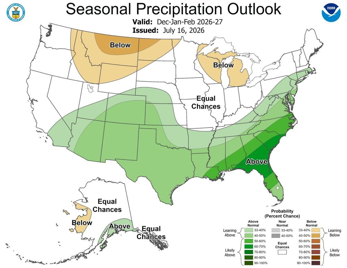
New NOAA seasonal outlook maps are giving Americans an early look at what winter 2026–27 could bring, including which parts of the United States may see wetter-than-normal conditions that could translate into more snow.

The latest maps from NOAA’s Climate Prediction Center cover the coming winter months and provide probability-based forecasts for temperature and precipitation. The newest outlook for January through March 2027 indicates above-average precipitation in parts of several states, although NOAA does not issue a nationwide seasonal map that directly predicts exactly how much snow each state will receive.
That distinction is important because precipitation can fall as rain, snow, sleet or freezing precipitation, depending on temperatures and elevation.
Which States Could See More Winter Precipitation?
NOAA’s latest precipitation outlook shows a wetter-than-normal signal across portions of the western and southern United States.
Areas of California, Arizona, New Mexico, Colorado, Nevada and Utah are among the regions receiving attention because increased precipitation combined with sufficiently cold temperatures could produce significant snowfall, especially in mountainous areas.
The outlook also shows above-average precipitation probabilities extending into parts of the southern Plains and Southeast.
However, warmer-than-normal temperatures are also expected across large portions of the country. That means increased precipitation does not automatically mean increased snowfall.
California Could Be One of the Key Snow Areas
California’s higher elevations are among the areas that could benefit from a wetter winter pattern.
The Sierra Nevada receives substantial snowfall during many winters, making seasonal precipitation forecasts particularly important for California’s mountain communities, ski resorts and water managers.
If colder temperatures coincide with increased precipitation, more of that precipitation could fall as snow at higher elevations.
Lower elevations are a different story. Warmer temperatures could mean that additional precipitation falls as rain rather than snow.
This is why NOAA’s map should be interpreted together with temperature forecasts rather than viewed as a direct snowfall prediction.
Colorado, Utah and Arizona Also Face Increased Snow Potential
Parts of the Southwest and southern Rocky Mountains are also attracting attention.
Colorado and Utah contain large areas of high terrain where winter precipitation frequently falls as snow. Arizona and New Mexico also have mountainous areas that can receive significant snowfall during cold-weather events.
NOAA’s seasonal precipitation outlook indicates wetter conditions across portions of these areas for the winter period.
But again, the amount of snow will depend on whether temperatures are cold enough when storms arrive.
For ski areas and mountain communities, elevation can make a major difference. A storm producing rain in a valley can produce heavy snow only a few thousand feet higher.
Why NOAA Does Not Simply Predict “Heavy Snow”
Long-range weather forecasting has important limitations.
NOAA’s Climate Prediction Center provides seasonal probabilities rather than precise storm-by-storm snowfall totals months in advance. Its seasonal outlooks show the likelihood of temperatures and precipitation being above, near or below normal.
A specific heavy snowstorm cannot be reliably forecast several months ahead.
Instead, meteorologists look at broad atmospheric patterns that influence where storms and moisture may be more common.
As winter approaches, shorter-range forecasts from the National Weather Service and Weather Prediction Center become much more useful for determining whether a particular storm will produce heavy snow.
The Weather Prediction Center provides snowfall probability maps for shorter forecast periods, including probabilities for snowfall reaching thresholds such as 4, 8 and 12 inches.
El Niño Could Influence Winter Weather
Another major factor being watched for winter 2026–27 is El Niño.
Large-scale changes in Pacific Ocean temperatures can influence the jet stream and storm tracks across North America.
The exact effects vary depending on the strength and location of the El Niño pattern. In some historical El Niño winters, the southern United States has experienced wetter conditions while some northern areas have been warmer or drier.
That general pattern is relevant to the latest seasonal outlook because several southern and southwestern areas are showing increased precipitation probabilities.
However, El Niño alone cannot determine whether a particular city will have a snowy winter.
Local temperatures, storm tracks, elevation and short-term atmospheric conditions all matter.
Northeast and Great Lakes Face a Different Situation
The Northeast and Great Lakes region also remains important when discussing U.S. winter weather.
Some areas may receive significant winter precipitation, but NOAA’s temperature outlook suggests that much of the country has increased odds of above-normal temperatures during portions of the winter period.
Warmer conditions can reduce the number of days when precipitation falls as snow, particularly at lower elevations.
At the same time, above-average seasonal temperatures do not eliminate the possibility of major snowstorms.
A region can have a warmer-than-average winter overall and still experience individual snowstorms when Arctic air and a strong storm system come together.
Southern States Could See More Precipitation
The latest NOAA maps also show wetter-than-normal conditions across portions of the southern United States.
States and areas including Texas, Louisiana, Mississippi, Alabama, Georgia, South Carolina and Florida are included in the broader wetter signal shown on the precipitation outlook.
But most of these areas are not expected to turn into major snow zones simply because precipitation is above average.
Temperature is the key factor.
For snow to occur, the atmosphere must be sufficiently cold through the relevant layers. Therefore, increased precipitation in a warm region is more likely to produce rain.
Winter Outlook Is Not a Snowfall Guarantee
People following the new maps should avoid interpreting them as a state-by-state snowfall guarantee.
NOAA’s seasonal outlook provides probabilities, not certainty.
For example, an area with an above-average precipitation signal does not mean every location within that area will receive more snow.
Likewise, a state with a warmer temperature outlook can still experience a major winter storm.
The maps are best viewed as an early indication of broad climate patterns rather than a prediction of individual storms.
When Will More Accurate Snow Forecasts Arrive?
More precise snowfall forecasts become possible as individual storms move closer.
NOAA’s Weather Prediction Center produces shorter-range winter-weather outlooks and snowfall probability maps. These products can identify the probability of accumulating snow during specific forecast windows.
That means Americans should use the current seasonal maps for long-term planning, while relying on local National Weather Service forecasts for actual snowstorm preparations.
What the New NOAA Maps Mean for Winter 2026–27
The latest outlook suggests that parts of the West and Southwest, particularly higher-elevation areas of California, Nevada, Utah, Arizona, New Mexico and Colorado, could have a greater chance of above-normal precipitation during the winter period.
Whether that precipitation becomes snow will depend heavily on temperature and elevation.
The broader picture is therefore more complicated than simply saying that certain states will have a “heavy snow winter.”
NOAA’s maps show where wetter or warmer conditions are more likely, while actual snowfall will depend on the interaction between moisture and cold air.
Final Takeaway
The new NOAA winter outlook provides an early look at winter 2026–27, with parts of the western and southern United States showing increased chances of above-normal precipitation.
For snowfall, the most important areas to watch include the higher elevations of California, Nevada, Utah, Colorado, Arizona and New Mexico.
But these are seasonal probabilities, not guaranteed snowfall forecasts. As winter gets closer, NOAA and the National Weather Service will provide much more specific information about individual snowstorms and accumulation risks.
About the Author