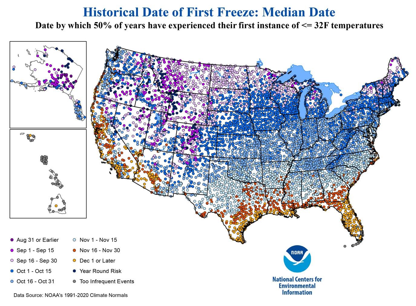


The first signs of fall are arriving across parts of the United States, and freeze and frost maps are showing when different parts of the country typically begin experiencing colder overnight temperatures.
As September progresses, northern parts of the U.S. can experience the first frost and freezing temperatures, while much of the Midwest generally sees its first freeze during October. Many southern states typically wait until November or later.
However, these maps should not be confused with a day-by-day weather forecast. They mainly show historical patterns and typical first-freeze dates. Actual conditions can vary significantly from year to year.
First Frost and Freeze Season Begins in Northern States
The transition toward colder weather is already becoming noticeable in parts of the northern United States.
Recent weather information shows frost and freeze concerns developing in parts of the northern tier, including areas of the Northeast and northern Rockies. The National Weather Service has also issued frost-related information for some northern locations as temperatures begin falling closer to freezing.
The first freeze does not arrive everywhere at the same time.
Higher elevations and northern locations can see freezing temperatures much earlier than lower-elevation areas farther south.
This means that even within the same state, one community may experience frost weeks before another.
What Is the Difference Between Frost and Freeze?
The terms frost and freeze are related but are not exactly the same.
A freeze generally occurs when temperatures fall to 32°F (0°C) or below. The National Weather Service uses this temperature threshold when discussing freeze conditions.
Frost can develop when surfaces become cold enough for ice crystals to form, sometimes even when the official air temperature is slightly above freezing.
A hard freeze is generally associated with temperatures around 28°F (-2.2°C) or lower and can cause much more serious damage to sensitive plants.
This distinction is particularly important for farmers, gardeners and people growing vegetables or other crops outdoors.
When Could the First Freeze Reach Different Parts of the U.S.?
The timing varies greatly across the country.
In some northern and mountainous locations, the first freeze can arrive as early as August or September. Across much of the Midwest and interior parts of the country, October is a more common period for the first freezing temperatures.
Southern states generally experience their first freeze later.
According to historical freeze information from the National Oceanic and Atmospheric Administration and National Weather Service, local conditions depend heavily on latitude, elevation, geography and proximity to large bodies of water.
A broad seasonal pattern looks like this:
| U.S. Region | Typical First Freeze Period |
|---|---|
| Northern Rockies / high elevations | August–September |
| Northern New England | September–October |
| Upper Midwest | September–October |
| Central Midwest | October |
| Mid-Atlantic | October–November |
| Southeast | October–November |
| Gulf Coast | November–December |
| Southern Florida | Later or occasional |
These are general patterns, not exact forecasts. Local weather can shift the timing considerably.
Why October Is Important for Much of America
October is a major transition month for large portions of the United States.
As daylight decreases and nights become longer, temperatures can fall quickly after sunset. Clear and calm nights are particularly favourable for frost formation because the ground can lose heat rapidly.
Historical maps from the National Weather Service show that first-freeze dates can vary even within relatively small areas. For example, parts of West Virginia can experience their first freeze in September, while lower and warmer areas may not normally reach freezing until October or later.
This is why looking at a map by state alone may not provide enough information.
Northern States Could See Cold Weather First
The northern tier is generally the first part of the contiguous United States to experience widespread freezing temperatures.
Recent reports indicate that parts of Idaho, Maine, New Hampshire, Vermont and New York have already faced frost concerns as September 2026 progresses.
The National Weather Service’s forecast discussions have also highlighted the potential for cooler air and first frosts or freezes in parts of the Northeast during late September.
For residents in these areas, sensitive outdoor plants may need protection as temperatures fall.
Midwest Could See More Freeze Risk in October
The Midwest typically experiences a significant increase in freeze risk during October.
States such as Minnesota, Wisconsin, Michigan, Iowa, Illinois, Indiana and Ohio contain large areas where the first freeze commonly arrives during September or October, although exact dates vary by location.
Farmers and gardeners pay close attention to these dates because a sudden freeze can damage crops that have not yet been harvested.
The first freeze also marks an important transition from the growing season toward the colder part of the year.
Southern States Usually Stay Warmer Longer
The southern United States generally has a longer growing season.
In parts of Texas, Louisiana, Mississippi, Alabama, Georgia and Florida, freezing temperatures usually arrive much later than in the northern states.
Some coastal and southern locations can go through much of the winter without experiencing a significant freeze.
Florida is an especially notable example because temperatures vary substantially between northern and southern parts of the state.
Historical climate information shows that some locations may experience freezing temperatures only occasionally.
Maps Are Not the Same as a Weather Forecast
One of the most important points for readers is that a first-freeze map does not tell you the exact day cold weather will arrive.
NOAA explains that its historical freeze maps are based on long-term climate records. The maps provide information about when a freeze has historically been expected in different locations.
The actual first freeze in 2026 could occur earlier or later.
Weather patterns can change rapidly, particularly during autumn when cold Arctic air can occasionally move southward.
For an actual near-term forecast, residents should check their local National Weather Service office and current forecast rather than relying only on a historical map.
Why Frost Maps Matter for Farmers and Gardeners
Freeze information is especially valuable for agriculture.
A single night below freezing can damage sensitive vegetables, flowers and young plants. Farmers may use frost forecasts to decide when to harvest crops or protect plants.
Gardeners can also use first-freeze information to prepare for the end of the growing season.
However, historical averages should be used as a planning tool rather than a guarantee.
What Happens Next?
As autumn progresses, the first freeze will gradually spread southward from northern and higher-elevation areas toward the central and southern United States.
The exact timing will depend on the movement of cold air, local geography and short-term weather patterns.
For now, the freeze maps provide a useful overview: northern and elevated areas generally face the earliest frost risk, much of the Midwest turns colder during October, while many southern areas remain frost-free for longer.
The best approach is to use the maps for seasonal planning and then check local forecasts as the expected freeze date approaches.
About the Author